Lowestoft to Ramsgate
Sun May 20th
Lowestoft- Shotley Point (Harwich) approximately 40 NM
After the weather we have been experiencing today is the total opposite, very little wind and from the North. This should be a straight forward sail without any problems by using the tide the distance should be covered in a reasonable time. We had thought of sailing to Dover but that would mean another 12 hrs sail and as time isn't as important now we will visit a couple of places on the way south.

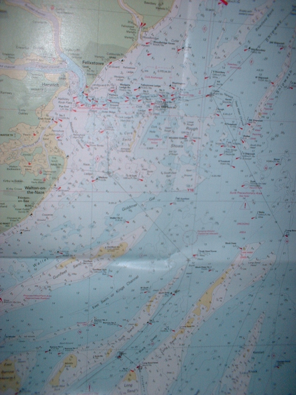
0800 hrs- 052'28-338N-001'45-137E 100 deg mag depart Lowesetoft 1014 Mb and rising. LW Harwich 0920hrs DST (LW Dover -0055 hrs). The tide will turn about 1 hour after LW giving us a fair tide for the passage, this is important as the tides here are in excess of 2 Kt. On leaving Lowestoft we book the passage plan with Yarmouth Coast Guard, giving ports of exit and entry, number of people on board and ETA, approx. 1600 hrs For the first time we are asked for our CG66 reg number 226206 and an international call sign MHKZ9.(Which we never use) so I give our MMSI instead 235023229. For the log I have decided to record every time we make a change of course or an hour sailing.
0830hrs-052'26-465N-001'47-189 178 deg mag 2.6 NM South Holm south cardinal buoy fairly straight forward, however a keen eye for the numerous unmarked pots.
0908hs-052'23-250N-001'47-359E 196 deg mag 4.18 NM Benacre Ness, positions were checked against sightings at least twice an hour to verify positions within the passage plan.
0954hrs-052'17-960N-001'45-121E 199 deg mag 5.63 NM position taken from GPS and sighting from the tower at Southwold to confirm we are on track. Another two bearings were taken in this section, from Sizewell power station an unmistakable building on the coast and form the distinct red and white light house at Orfordness at 1136 hrs
1152hrs-052'01-900N-001'38-226E 16.42 NM North Shipwash NCM, we need this to locate the entrance to the channel that will take us to Harwich. Harwich has like many ports a designated yacht channel for approach and departure, this is to ensure the reduced risk of interaction between heavy commercial vessels and pleasure vessels.
1252hrs-051'56-057N-001'31-150E 5.36 NM Clear water mark (ball)1311hrs-051'55-204N-001'26-141E 1.94 NM Cork sands yacht track.
1444hrs-051'57-562N-001'16-632E Shotley point marina.
It's all right for a stop over. It's isolated on the point of two rivers, a ferry
trip in the morning to Harwich doesn't get any better. So we return to the boat
and begin planning the next passage of the trip which is to be Ramsgate.
Shotley point£17.50 per night for a 10 m boat, electricity extra, works out at £21 a night. Laundry£3.50 a shot(expensive) won't go back unless a storm blows us in.
Tues May 22nd

Harwich-Ramsgate approx 40 NM
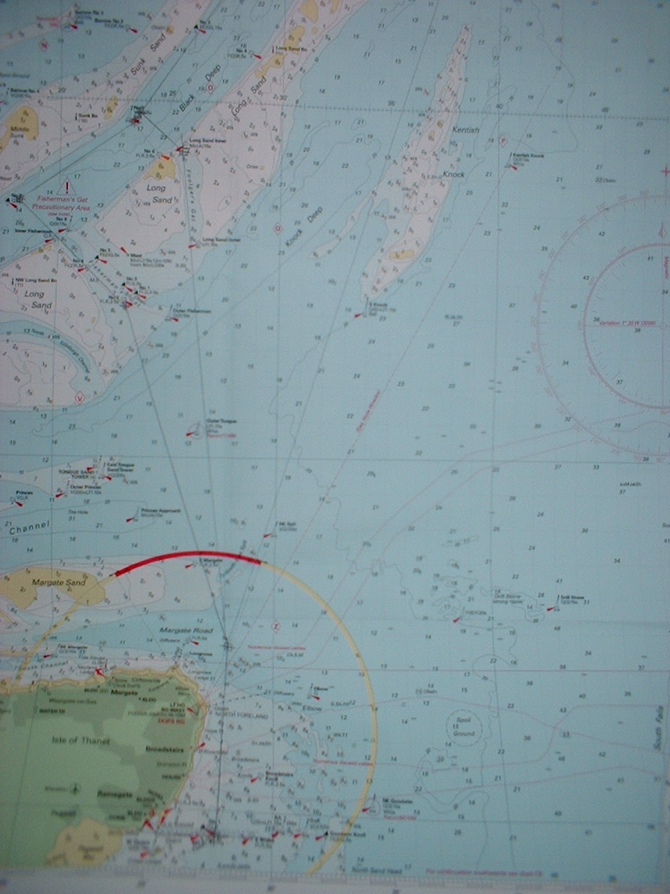
This is the most difficult leg yet, we have to negotiate the Tames estuary with all the traffic and pick up various shoal channels through the passage or take a fifty mile trip the long way round.
0900hrs-051'57-562N-001'16-632E lock out of Shotley point
1000hrs-051'54-25N-001'20-888E Foxs Buoy 147 deg mag 3.95 NM
1027hrs-051'51-596N-001'21-476E Medusa Buoy 143 deg mag 2.44 NM
1102hrs-051'4-277N001'25-036E sighting 140 deg mag 2.83 NM
1140hrs-051'46-487N-001'29-218E Sunk NCM 194 deg mag 3.65 NM
1204hrs-051' 44-440N-001'28-804E Black Deep No 1 CM 224 deg mag 1.73 NM
This next step was to be the tricky bit as we had to find a channel 5 meters deep and only 300 m wide at this end, bearing in mind, this is by now 15 mile or so out to sea we are surrounded by drying sand banks waiting for you to run aground.
1245hrs-051'40-160N-001'24-035E a point in front of the No 5 Black deep bell to turn to a heading of 158 deg mag and enter the Foulgers Gat channel, if you get it wrong you end up on Long Sands a drying bank of 1.3 m above chart datum, which you can't see on a rising tide, to the south west
1305 hrs 051'38-745N-001'25-703E Foulgers Gat entrance 184 deg mag 1.9 NM watching the depth gauge constantly this part of the channel has a minimum of 5 meters if you get it right. The water begins to deepen and then shoal to 3 m and deepen again, we both breath again after 5 mile and the water depths begin to read 15+ meters.
 The Seamans Church at Ramsgate
1705 hrs 051'19-702N-001'25-231E Ramsgate Royal Harbour. Total distance of 39.8 NM using the tide gave us an advantage of at least an hour, however we still had to push a fowl tide for he last hour this we increasing up to 2 kt When we arrived the Grand Turk was in harbour, an old three masted sailing ship that had taken place in the Tall Ships race of 2006.
Ramsgate
£21.00 for 10 m, showers free, water and electricity included the town is well worth a visit with good food and beer. Nice helpful people.
Next step 15 mile to Dover Thursday weather permitting.(yeh right)
 The Dutch at Ramsgate